How Do I Get a Plan of My Property?
Obtaining a plan of one's property, often referred to as a property survey, site plan, or plat, is a crucial step for various reasons. These reasons range from resolving boundary disputes with neighbors to facilitating property development and ensuring compliance with local zoning regulations. This document serves as a visual representation of the property's boundaries, dimensions, and features, providing essential information for property owners, potential buyers, and relevant authorities.
The process of acquiring a property plan can appear complex, but with a systematic approach, it becomes manageable. This article details the methods available for obtaining a property plan, the information contained within the plan, and the considerations involved in selecting the most appropriate approach.
Understanding the Purpose of a Property Plan
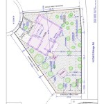
Before embarking on the process of obtaining a property plan, it is essential to understand its purpose and the type of information it provides. A property plan is a scaled drawing that depicts the boundaries and significant features of a specific parcel of land. The information typically included in a property plan encompasses:
*Boundary Lines: The plan clearly delineates the property's boundaries, indicating its dimensions and spatial relationship with adjacent properties. This helps to avoid boundary encroachments and disputes.
*Easements and Rights-of-Way: Any easements or rights-of-way affecting the property are shown, indicating areas where others have the right to access or utilize the land for specific purposes, such as utility lines or access roads.
*Building Locations: The plan illustrates the locations of existing structures on the property, including houses, garages, sheds, and other buildings. This information is crucial for determining building setbacks and compliance with zoning regulations.
*Topography: Some property plans include topographic information, depicting the elevation changes on the property. This is particularly important for properties with significant slopes or drainage issues.
*Utilities: The location of underground utilities, such as water lines, sewer lines, and gas lines, may be indicated on the plan, although utility companies are a more reliable source for detailed utility maps.
*Landmarks: Significant landmarks, such as fences, trees, and water features, may be included as reference points.
The specific details included in a property plan can vary depending on the purpose of the plan and the requirements of local authorities. It is important to clarify the specific information needed before initiating the process of obtaining the plan.
Methods for Obtaining a Property Plan
Several methods are available for obtaining a property plan, each with its own advantages and disadvantages. The most appropriate method depends on the specific circumstances, the availability of existing records, and the desired level of accuracy.
*Reviewing Existing Records: The first step in obtaining a property plan should be to review any existing records related to the property. These records may be available from various sources, including:
*Local Government Offices: The county recorder's office, assessor's office, or planning department may have copies of property plans, deeds, and other relevant documents. These records are often publicly accessible, although fees may apply for copies.
*Title Companies: If a title company was involved in a previous property transaction, they may have a copy of the property plan in their records.
*Mortgage Lenders: Mortgage lenders may also have copies of property plans in their loan files.
*Previous Owners: If possible, contacting previous owners of the property can be a valuable resource for information and documents related to the property.
Existing records may provide a sufficient level of detail for some purposes. However, it is important to verify the accuracy and completeness of these records, as they may be outdated or incomplete. If the existing records are insufficient, a new survey may be necessary.
*Ordering a New Survey: If existing records are unavailable or insufficient, the most reliable method for obtaining a property plan is to hire a licensed land surveyor to conduct a new survey. Land surveyors are professionals specifically trained and licensed to accurately measure and map properties. The process typically involves:
*Selecting a Surveyor: It is important to select a licensed and experienced land surveyor who is familiar with the local area and regulations. Checking online reviews, obtaining references, and verifying licensing credentials are crucial steps in the selection process.
*Defining the Scope of Work: Clearly define the scope of work with the surveyor, specifying the type of survey required and the information to be included in the plan. Different types of surveys are available, including boundary surveys, topographic surveys, and construction surveys. The type of survey required will depend on the specific purpose of the plan.
*Conducting the Survey: The surveyor will conduct a field survey of the property, using specialized equipment to measure the boundaries, locate existing structures, and identify any easements or rights-of-way. The surveyor will also research existing records to establish the legal boundaries of the property.
*Preparing the Plan: Based on the field survey and research, the surveyor will prepare a detailed property plan that accurately depicts the property's boundaries, dimensions, and features. The plan will be signed and sealed by the surveyor, certifying its accuracy and compliance with applicable regulations.
Ordering a new survey is the most accurate and reliable method for obtaining a property plan, but it is also the most expensive. The cost of a survey will depend on the size and complexity of the property, as well as the type of survey required.
*Using Online Mapping Tools: Several online mapping tools, such as county GIS (Geographic Information System) websites or third-party mapping platforms, offer access to property information and aerial imagery. These tools can provide a general overview of the property and its surroundings, but they are not a substitute for a professional survey. The accuracy of online mapping tools can vary, and they should not be relied upon for legal or official purposes.
While online mapping tools can be helpful for preliminary research and visualization, they should be used with caution and verified with other sources of information.
Key Considerations When Obtaining a Property Plan
Several key considerations should be taken into account when obtaining a property plan, ensuring that the plan meets the specific needs and requirements.
*Accuracy Requirements: The required level of accuracy for the property plan will depend on its intended use. For example, a boundary survey for resolving a boundary dispute will require a higher level of accuracy than a site plan for landscaping purposes. Clarify the accuracy requirements with the surveyor before initiating the survey.
*Compliance with Local Regulations: Property plans must comply with all applicable local regulations and standards. These regulations may specify the format, content, and accuracy requirements for property plans. Ensure that the surveyor is familiar with these regulations and that the plan meets all requirements.
*Budget: The cost of obtaining a property plan can vary significantly depending on the method used and the complexity of the property. Establish a budget for the project and obtain quotes from multiple surveyors before making a decision.
*Turnaround Time: The time required to obtain a property plan can also vary depending on the method used and the surveyor's workload. If the plan is needed by a specific deadline, communicate this to the surveyor and ensure that they can meet the deadline.
*Legal Implications: Property plans have legal implications, particularly in cases involving boundary disputes or property transactions. Ensure that the plan is accurate and reliable, and consult with an attorney if necessary.
By carefully considering these factors, individuals can navigate the process of obtaining a property plan effectively and ensure that the plan meets their specific needs and requirements. Selecting a qualified surveyor, clarifying the scope of work, and verifying compliance with local regulations are essential steps in obtaining a reliable and accurate property plan.

How Do I Get A Floor Plan For My Property

How To Obtain A Site Plan Of My Property

9 Ways To Find Floor Plans Of An Existing House Blueprints Archid

Simple Plot Plan My Site

Where Can I Get A Site Plan Of My Property Weldplus

Detailed Site Plan Residential Commercial Plans My

Simple Plot Plan My Site

Membuat Peta Site Plan Lahan Di Google Maps How To Create A Property Map With

Medium Site Plan Residential My

Medium Site Plan Residential My
Related Posts


