```html
What Scale Is A Site Plan?
A site plan is a detailed architectural drawing that illustrates the existing and proposed conditions of a specific parcel of land. It serves as a comprehensive visual representation used for various purposes, including obtaining building permits, guiding construction activities, and facilitating communication between stakeholders involved in a development project. One of the most crucial aspects of a site plan is its scale, which directly impacts the level of detail and the accuracy of the information conveyed. Consequently, understanding the appropriate scale for a site plan is paramount for effective planning, design, and execution.
The scale of a site plan is expressed as a ratio that represents the relationship between the distance on the drawing and the corresponding distance on the ground. For example, a scale of 1:100 signifies that one unit of measurement on the site plan (e.g., one centimeter or one inch) corresponds to 100 units of the same measurement on the actual site. The selection of an appropriate scale depends on several factors, including the size of the site, the complexity of the project, the intended use of the site plan, and any regulatory requirements.
Choosing the correct scale is essential. A scale that is too small may not provide sufficient detail to show important features, while a scale that is too large may be unwieldy and difficult to manage. The objective is to strike a balance that allows for clear and accurate representation of the site's characteristics and proposed improvements.
Factors Influencing Site Plan Scale Selection
Several key factors need careful consideration when determining the appropriate scale for a site plan. These factors directly influence the clarity, accuracy, and usability of the drawing.
Site Size and Complexity: The size of the property being represented is a primary determinant of the site plan scale. A small residential lot can typically be depicted at a larger scale, such as 1:50 or 1:100, allowing for precise representation of building footprints, landscaping details, and utility locations. Conversely, a large commercial or industrial site encompassing several acres may necessitate a smaller scale, such as 1:200, 1:500, or even 1:1000, to accommodate the entire area on a manageable drawing sheet. The complexity of the site, including variations in topography, existing structures, and natural features, also plays a role. More complex sites usually benefit from larger scales to adequately illustrate these elements.
Information Requirements: The intended use of the site plan dictates the level of detail required and, consequently, the appropriate scale. A site plan used for conceptual design and preliminary planning may be prepared at a smaller scale, focusing on overall site layout and relationships between buildings and circulation patterns. However, a site plan submitted for building permit approval needs to provide significantly more detail, including precise dimensions, setbacks, grading information, utility locations, and compliance with zoning regulations. These detailed site plans typically require larger scales to accurately represent all required information. For example, showing the precise location of a fire hydrant or the slope of a driveway often requires a larger scale than planning the overall layout of parking spaces.
Regulatory Requirements: Local zoning ordinances, building codes, and other regulations often specify minimum scale requirements for site plans submitted for review and approval. These requirements are intended to ensure that the submitted drawings provide sufficient detail for regulatory authorities to assess compliance with applicable regulations. It is crucial to consult with the relevant planning department or building authority to determine the specific scale requirements for a particular project. Ignoring these requirements can lead to delays in the approval process or even rejection of the application. These regulations often consider the type of project. A commercial project might have stricter scale requirements than a residential project because of its complexity and potential impact.
Commonly Used Site Plan Scales
While the optimal scale for a site plan depends on the specific project and regulatory context, certain scales are more commonly used than others. These commonly used scales provide a practical balance between detail and manageability.
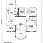
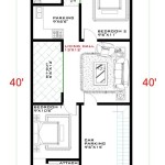
1:50 (1 inch = 4 feet): This scale is often used for detailed site plans of small residential properties or specific areas within a larger development. It allows for the precise representation of building dimensions, landscaping features, paving materials, and utility locations. At this scale, even minor details can be clearly illustrated, making it suitable for construction drawings and detailed design plans.
1:100 (1 inch = 8 feet): This is a frequently used scale for a wide range of site plans, including residential, commercial, and industrial projects. It provides a good balance between overall site coverage and level of detail. It's often preferred for site plans submitted for building permits, as it allows for the depiction of essential information such as building setbacks, parking layouts, and drainage patterns.
1:200 (1 inch = 16 feet): This scale is suitable for larger sites where a high level of detail is not required. It's commonly used for preliminary site planning, conceptual design, and overall site layout. While it may not be appropriate for detailed construction drawings, it's useful for depicting the relationships between buildings, roadways, and other major site elements.
1:500 (1 inch = 40 feet) and 1:1000 (1 inch = 80 feet): These smaller scales are typically used for very large sites, such as industrial parks, large-scale residential developments, or master planned communities. At these scales, the emphasis is on representing the overall site organization and relationships between different areas. Detailed features are typically omitted, and the focus is on the broader context of the development.
In addition to these metric scales, imperial scales are also common, particularly in the United States. Common imperial scales include 1 inch = 10 feet, 1 inch = 20 feet, 1 inch = 30 feet, 1 inch = 40 feet, and 1 inch = 50 feet. The choice between metric and imperial scales often depends on local conventions and the preferences of the design professionals involved.
Consequences of Selecting an Inappropriate Scale
Choosing an inappropriate scale for a site plan can lead to several negative consequences, affecting the project's design, approval process, and construction phase.
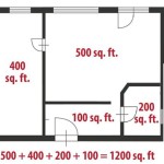
Loss of Detail and Accuracy: If the scale is too small, important features may be difficult or impossible to represent accurately. This can lead to misunderstandings, errors in construction, and non-compliance with regulations. For example, if the scale is too small to show the precise location of utility lines, it could result in damage during excavation. Similarly, inaccurate representation of building setbacks can lead to zoning violations.
Difficulty in Interpretation: A site plan that is too crowded or lacks clarity due to an inappropriate scale can be difficult to interpret. This can hinder communication between architects, engineers, contractors, and regulatory authorities. Ambiguity in the site plan can lead to misinterpretations and delays in the approval process. For instance, if the scale is too small to clearly distinguish between different types of paving materials, it could lead to confusion during construction and potentially incorrect installations.
Increased Risk of Errors and Omissions: An inappropriate scale can increase the risk of errors and omissions in the site plan. Important dimensions may be miscalculated, and critical features may be overlooked. This can result in costly rework during construction and potentially compromise the overall quality of the project. For example, if the scale is too small to accurately represent the topography of the site, it could lead to errors in grading and drainage design, resulting in flooding or erosion problems.
Selecting the right scale for a site plan necessitates a thorough understanding of the project's scope, the specific information needed, and applicable regulatory requirements. Consulting with experienced architects, engineers, and planning professionals is highly recommended to ensure that the chosen scale is appropriate and that the site plan effectively communicates all necessary information. Failure to do so can result in significant delays, increased costs, and potential legal issues.
```
Site Plan Designing Buildings

Site Plan Wikipedia

Resources

What Is An Architectural Site Plan

Simple Site Plan Tacoma Permits

A Guide To Creating Your Site Location Plan

The Site Plan 1 500 Scale By Reem Al Shawbkeh Dar Uloom Scientific Diagram

What Is A Site Plan Definition Elements And Examples

What Is A Site Plan Definition Elements And Examples

How To Create A Site Plan 8 Simple Steps Cedreo
Related Posts